Drones
Keep up to date with the latest commercial and civilian applications of unmanned aircraft – from autonomous sky-faring taxis to swarms of battlefield-ready flying robots.
Latest News
-
Solar-cell-packin' drone uses sunlight for on-the-spot recharging
April 19, 2024Multirotor drones may one day be able recharge their batteries while out and about, instead of having to return to a charging station. They could do so via onboard ultra-thin solar cells, which have already been tested on a small quadcopter. -
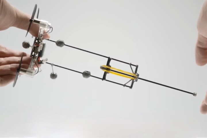
Video: Ultra-efficient flying pogo robot bounces around on its tail
April 12, 2024It might look hilarious in motion, but this remarkable aerial drone extends its battery life from a few minutes up to a full hour by bouncing around on a springy pogo tail. That incredible efficiency makes it attractive for a wide range of missions. -
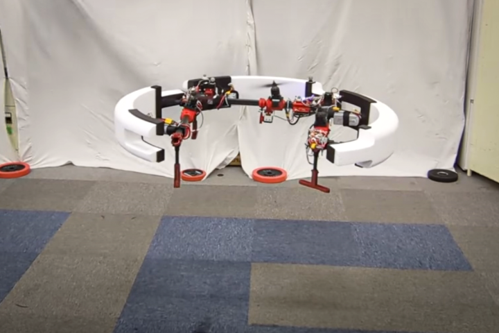
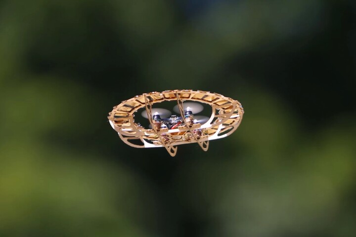
Video: Deformable ring drone morphs into a rolling wheel to boost runtime
April 08, 2024A new experimental drone can fly in the air as needed, then morph into a motorized wheel and roll on the ground to save energy. It could one day find use in applications such as searching disaster sites for victims trapped in the rubble. -

Video: Crafty quadcopter sits on power lines to recharge
April 05, 2024Battery life wouldn't be an issue for drones if they could just recharge on power lines as needed. That's exactly what an experimental new quadcopter can now do, allowing it to stay aloft pretty much indefinitely. -

Streamlined "submersible quadcopter" is an underwater inspector gadget
March 19, 2024The Chasing X brings a new form factor to mini ROVs, looking a bit like a submersible quadcopter. It's designed mainly for the underwater inspection of things like ship hulls and aquaculture operations, although it can also grab stuff if need be. -

"Flying milk can" drones to start drop-delivering food in Sweden
March 18, 2024People living in part of Sweden will soon be receiving food deliveries by drone. The service, which utilizes multicopters that look rather like old-timey milk transportation cans, may subsequently be introduced throughout the country and beyond. -

Mosquito-spreading drones could slash the spread of disease
February 23, 2024If you're trying to disperse 300,000 disease-fighting mosquitos per day, using a drone may well be your best bet for doing so. The technology has already been tested in Brazil, where it showed very promising results. -
Auto-follow chopsticks grab flying UAVs from the back of a vehicle
February 04, 2024Mesmerizing video shows Teledyne FLIR's new autonomous drone-catching cradle matching the movements of a model helicopter and grabbing it the instant it's within reach. It'll allow soldiers to launch and recover drones from inside their vehicles. -

Huntress hybrid drone packs a 300+ mph turbojet core
January 30, 2024Connecticut-based WaveAerospace has announced "the world's fastest multirotor UAS," a "new class of aircraft" that's effectively a quadcopter drone with a raging jet turbine in the middle, capable of insane speeds and all-weather operation. -
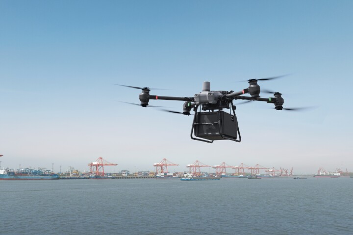
DJI announces its first-ever delivery drone, the FlyCart 30
January 18, 2024Although DJI is probably the best-known manufacturer of consumer drones, it hasn't ventured into the world of delivery drones … until last week, that is. The company's FlyCart 30 (FC30) is now set to join the growing ranks of package-toting copters. -
Shipping-pallet-friendly Orca cargo drone is designed to fit in
January 17, 2024In order for cargo drones to be widely adopted, it helps if they're compatible with the shipping infrastructure. The creators of the Orca drone have kept that in mind, as their aircraft will take payloads stacked on standard-size shipping pallets. -

Evolution Eagle drone flips the bird at enemy forces
January 15, 2024If you're conducting covert military reconnaissance, you probably don't want the enemy seeing what's obviously a drone flying overhead. That's where the Evolution Eagle is intended to come in, as it's a drone that just looks like a big ol' bird. -

"Flying dragon" robot harnesses the "crazy hose" effect to fight fires
December 21, 2023Japanese researchers have created and open-sourced a flying firefighting hose that levitates and steers itself to fight fires using its own water pressure as a two-part propulsion system, spraying water down onto fires and keeping operators safe. -
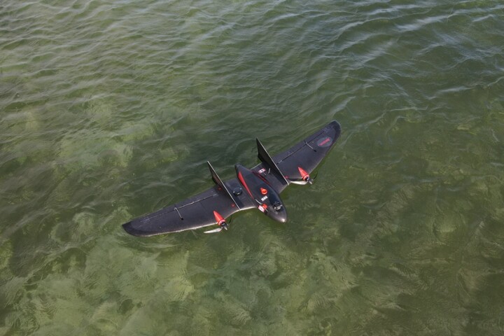
VT-Naut fixed-wing drone takes off vertically and makes water landings
December 19, 2023If you've ever tried flying a drone, you'll know how hard it can be to land one in just the right place … now imagine trying to land one on a boat out at sea. The VT-Naut is designed to make things easier, by performing belly landings on the water. -

ThunderFly TF-G1 autogyro drone is up for stormy weather
December 11, 2023Although drones are a good substitute for piloted aircraft in hazardous weather conditions, it's obviously still best for their users if the things don't crash. The Czech-designed ThunderFly TF-G1 autogyro drone was created with that fact in mind.
Load More