Military

DARPA program plunges into underwater positioning system

DARPA program plunges into underwater positioning system
BAE Systems will develop undersea positioning technology that will make use of long-range acoustic sources at fixed locations around the ocean
View 1 Image
BAE Systems will develop undersea positioning technology that will make use of long-range acoustic sources at fixed locations around the ocean
1/1
BAE Systems will develop undersea positioning technology that will make use of long-range acoustic sources at fixed locations around the ocean

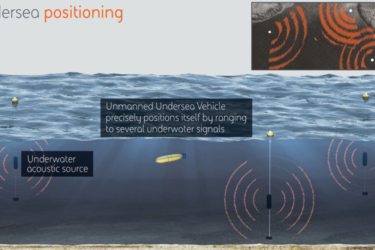
It can guide the Uber driver to our doorstep and steer mortar rounds toward their targets in Afghanistan, but one place GPS falls short is underwater. The seas may soon have high-precision positioning systems of their own, however, through a DARPA program aimed at providing US Navy submersibles with a new means of navigating the ocean's depths.

The radio signals broadcast by orbiting GPS satellites reach all corners of the globe, but are brought to a halt at the water's surface. While this is obviously problematic if you carry out most of your business beneath the seas, underwater vehicles can partially solve this problem by coming up to the surface every so often.

The trouble is, this increases the chances of detection when operating in hostile environments, and considering that enemies might jam the signal anyhow, it could be a dangerous exercise in futility.

So DARPA has enlisted the services of BAE Systems, along with not-for-profit research company Draper, to develop a system that will allow for GPS-like precision while underwater. The program is called the Positioning System for Deep Ocean Navigation (POSYDON) and, if all goes to plan, will allow the navy's submersibles to remain concealed by the ocean while accurately navigating.

To achieve this, BAE is developing technology that makes use of long-range acoustic sources at fixed locations around the ocean. It has also been set the task of developing the necessary instruments for the vehicles to pick up and process these signals in order to find their way around.

In the same way that GPS receivers rely on the signals from multiple satellites to calculate a precise positon, the undersea vehicles would discern their location by ranging to the acoustic signals from several of the fixed underwater sources.

"BAE Systems has more than 40 years of experience developing underwater active and passive acoustic systems," said Joshua Niedzwiecki, director of Sensor Processing and Exploitation at BAE Systems. "We'll use this same technology to revolutionize undersea navigation for the POSYDON program, by selecting and demonstrating acoustic underwater GPS sources and corresponding small-form factor receivers."

Source: BAE Systems

9 comments
9 comments
Mel Tisdale
If GPS satellite signals can be jammed, so can these signals. That said, spread the receivers about the oceans and it should be possible to establish the location of enemy submersibles, at least while on the move (every watercraft generates a unique sound signature). If nothing else, it could provide confirmation of other sources. I suppose that this system enhances counter-force capability for all submarine based ballistic missiles - ho hum - let's hope our luck doesn't run out like it almost did on occasion during the last Cold War.
Gringo
Interesting, but there's really nothing ground breaking about a low frequency LBL ( long base-line) acoustic navigation system. These systems have been in use for fifty years or more, along with SBL (Short Baseline) and USBL (Ultra-short baseline) acoustic positioning systems. Low frequencies are good for long distance, with reduced accuracies. High frequency systems are much greater accuracy, but at limited acoustic range. If, as the article states, the subs will navigate by ranging to the transponders, then it's an active system requiring the subs to initiate the acoustic handshake in order to time the travel time to the transponders and back and determine range for triangulation. This means the subs are making noise. So perhaps the new part of this is the coding or whatever triggering scheme is in use. But navigating undersea relative to a transponder network is old hat.
Gizmowiz
If this worked well why couldn't it be adapted to aviation for flights over the seas such that all planes would have sensors able to be identified and located in the event a plane crashes into the ocean? It would mean a lot of ocean coverage and expensive I'm sure.
JimPike
I hope it doesn't affect whales and dolphins.
Mark Martin
To hell with the marine life
WilliamAWallner
Aviators already have such a system, for over land. It is called VORTAC. (VOR is for civilian aviation and TAC is military.) Same principles: a discreet signal broadcast over a 360º radius. Tune to 2 of them and use triangulation to get a darn good fix. Substitute acoustic waves for radio waves and, job done. Not sure why that would not eliminate the need for a GPS surface connection. You would know where the beacon is. It is attached to the sea bed. And, wouldn't the cable to the surface present a nearly invisible, to SONAR, hazard to submerged.
CliffG
Mark Martin wrote, "To hell with the marine life." If you are serious, then I assure you that is not an acceptable stance. The consequences of this acoustic positioning system on marine live will depend on the intensity, frequency, and duty cycle of the signals. In order to propagate useful distances they will need to be low frequency and powerful. I don't see this ever happening on a useful scale.
lgilbert50
I guess the government wants to eliminate the ocean mammals.
Vivek
@Mel Tisdale
Unlike GPS, frequencies used in this application are likely to be secret, and frequency hopping can be employed to thwart jamming without harm to non-military activities. Obviously, there are some kinks in this, but it's likely to be more secure than GPS when it is operational.