Science
The latest in science news, from the depths of space to the quantum realm.

Camera captures the world as animals see it, with up to 99% accuracy
January 25, 2024
It’s easy to forget that most animals don’t see the world the way humans do. In fact, many perceive colors that are invisible to us. But now, for the first time, scientists have found a way to capture footage as seen by animals, and it's mesmerizing.
Energy
-

World first energy storage unit demonstrates zero degradation over 5 years
April 15, 2024China's CATL – the world's largest EV battery producer – has launched TENER, which is described as the "world's first mass-producible energy storage system with zero degradation in the first five years of use." -

90-GWh thermal energy storage facility could heat a city for a year
April 09, 2024An energy supplier in Finland has announced the upcoming construction of an underground seasonal thermal energy storage facility about the size of two Madison Square Gardens that could meet the heating demands of a medium-sized city for up to a year. -

Condor-inspired retrofit boosts wind turbine energy production by 10%
April 03, 2024The Andean condor’s drag-reducing aerodynamic wings have inspired the creation of a winglet, which, when added to a wind turbine blade, boosted energy production by an average of 10%, according to a new study.
Load More
Medical
-

Light-activated propulsion spins bacteria-shredding micromotors
April 18, 2024The four spikes on a new nanocrystal developed in Spain spin up under light and move through liquid, blasting any bacteria unfortunate to be in their path. The development could spell trouble for bacteria that resists traditional drug treatments. -

New flu drug aims to keep you in a 'Goldilocks zone' of lung inflammation
April 12, 2024A new drug for severe influenza successfully keeps patients at the perfect level of lung inflammation to protect against lung damage while still allowing the immune system to fight off the infection. It's effective in mice even days after infection. -

Sleep apnea: Mouthguards less invasive, just as effective as CPAP
April 12, 2024Obstructive sleep apnea can cause or contribute to high blood pressure, so a new study examined which sleep apnea treatments – a CPAP machine or a mouthguard that keeps the airways open – was more effective at lowering blood pressure.
Load More
Space
-
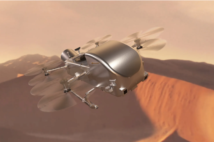
Dragonfly rotorcraft given green light for mission to Titan
April 17, 2024NASA has given the green light for the nuclear-powered Dragonfly rotorcraft to explore Saturn's largest moon, Titan. Approval for the 2028 interplanetary mission comes after years of delay due to COVID-19 and a series of cost overruns. -

Space junk that tore through Florida home was from ISS, confirms NASA
April 16, 2024NASA has completed the analysis of a chunk of metal that crashed into the roof of a house in Naples, Florida, a few weeks ago. The agency says it came from a pallet of trash released from the International Space Station three years ago. -

NASA's electrodynamic dust shield will repel clingy, abrasive Moon grit
April 15, 2024Future Moon bases may be a bit tidier thanks to an electric shield that protects equipment from destructive lunar dust. NASA's Electrodynamic Dust Shield (EDS) technology promises to tame the destructive dust that clings to equipment.
Load More
Materials
-

Goldene: New 2D form of gold makes graphene look boring
April 16, 2024Graphene is the Novak Djokovic of materials – it’s so damn talented that it’s getting boring celebrating each new victory. But an exciting new upstart is challenging graphene’s title. Meet goldene, a 2D sheet of gold with its own strange properties. -
Graphite platform levitates without power
April 10, 2024Magnetic levitation is used to float things like lamps and trains, but usually it requires a power source. Now, scientists in Japan have developed a way to make a floating platform that requires no external power, out of regular old graphite. -

Harvard's bizarre "metafluid" packs programmable properties
April 09, 2024Harvard engineers have created a strange new “metafluid” – a liquid that can be programmed to change properties, like its compressibility, transparency, viscosity and even whether it’s Newtonian or not.
Load More
Biology
-

Two lifeforms merge in once-in-a-billion-years evolutionary event
April 18, 2024Scientists have discovered that a once-in-a-billion-years evolutionary event is underway, as two lifeforms have merged into one organism that boasts abilities its peers would envy. Last time this happened, Earth got plants. -

The surprising reason we blink so much more than we need to
April 16, 2024Blinking keeps our eyes moist – but we actually blink way more often than we need to if that was the only reason. Scientists have now found that the involuntary action plays a bigger role than we thought, helping us process visual information. -
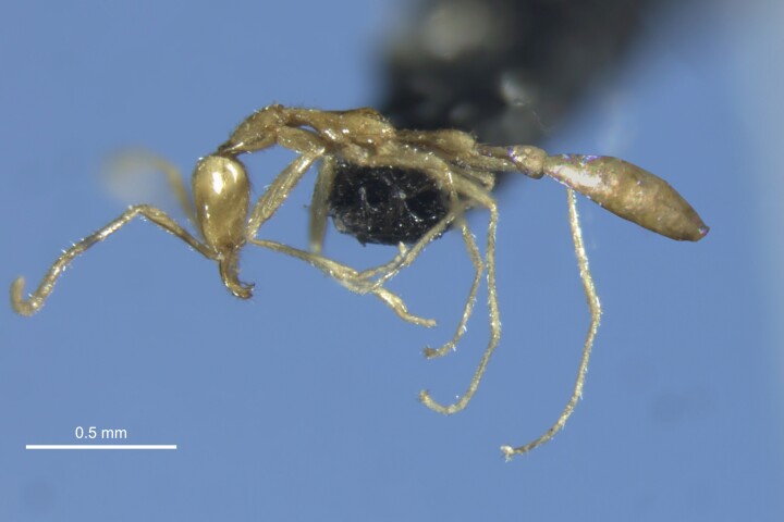
Freaky 'Leptanilla voldemort' ant earns its name in the darkness
April 15, 2024A new ant has been named after the creepiest of all Harry Potter villains, Lord Voldemort. Like the lord, the ant is pale, slender and lives in the dark – unlike Mr. Voldemort, however, the ant did not give Harry his lightning-bolt forehead scar.
Load More
Environment
-

Self-dying bacterial black leather paves the way for greener textiles
April 04, 2024Bacteria-produced leather is already an eco-friendly alternative to its cow-derived counterpart, but it could soon be even eco-friendlier. Scientists have gotten the microbes to color the stuff themselves, eliminating the need for toxic dyes. -
"First plastic demonstrated to not create microplastics" has been tested
March 22, 2024Even when it’s ground into microparticles, 97% of an algae-based plastic biodegrades in compost and water in under seven months, a new study has reported. The researchers hope their plastic will eventually replace existing petroleum-based ones. -

Winged cargo ship saves three tonnes of fuel per day on first voyage
March 19, 2024An age of greener, more efficient shipping may be in the offing as a specially modified 43,000-tonne bulk freighter completes a six-month sea trial using a combination of diesel engines and a set of high-tech automatic sails to catch the wind.
Load More
Physics
-

Free software lets you design and test warp drives with real physics
April 16, 2024Warp drives are among the more plausible of science fiction concepts, at least from a physics perspective. Now, a group of scientists and engineers has launched open-source software that lets you design and test scientifically accurate warp drives. -

Professor Peter Higgs, renowned for Higgs boson prediction, dies aged 94
April 09, 2024Professor Peter Higgs has died aged 94. The theoretical physicist was best known for his prediction of a key elementary particle, the Higgs boson, which earned him the 2013 Nobel Prize in Physics soon after its discovery. -

Quantum tornado mimics black holes' warped spacetime in the lab
March 21, 2024A giant quantum vortex has been created in superfluid helium in a lab at the University of Nottingham. Its behavior was found to mimic that of black holes and may help astrophysicists gain deeper insight into these galactic gravity gobblers.
Load More
Electronics
-

AI synthesizer bridges technology and creativity in music composition
February 15, 2024SPIN challenges conventional notions of music creation by inviting users to collaborate with an AI language model called MusicGen. With its distinctive blend of a turntable and a drum machine, SPIN offers users a creative music composition tool. -

Eye-tracking window tech tells sightseers about what they're looking at
January 05, 2024If you're on a sightseeing tour in a bus, you really don't want to be looking away from the passing attractions to Google them on your smartphone. The AR Interactive Vehicle Display is intended to help, by showing relevant information on the vehicle's window glass. -

Diamond data storage breakthrough writes and rewrites down to single atom
December 05, 2023Diamond is a promising material for data storage, and now scientists have demonstrated a new way to cram more data onto it, down to a single atom. The technique bypasses a physical limit by writing data to the same spots in different-colored light.
Load More
Quantum Computing
-
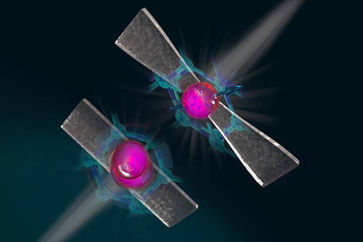
Diamond-stretching technique makes qubits more stable and controllable
November 30, 2023Researchers are claiming a breakthrough in quantum communications, thanks to a new diamond-stretching technique they say greatly increases the temperatures at which qubits remain entangled, while also making them microwave-controllable. -
Perovskite LED unlocks next-level quantum random number generation
September 05, 2023Random numbers are critical to encryption algorithms, but they're nigh-on impossible for computers to generate. Now, Swedish researchers say they've created a new, super-secure quantum random number generator using cheap perovskite LEDs. -

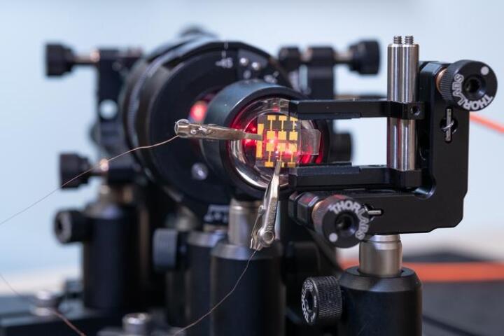
Silicon quantum computing surpasses 99% accuracy in three studies
January 19, 2022Three teams of scientists have achieved a major milestone in quantum computing. All three groups demonstrated better than 99 percent accuracy in silicon-based quantum devices, paving the way for practical, scalable, error-free quantum computers.
Load More