GPS
-
 While GPS can be used to determine one's geographical coordinates on land, such is not the case underwater. Scientists have developed an alternative, however, in the form of a system that analyzes the manner in which sunlight is polarized by water.
 -
 GPS-enabled tracking collars allow scientists to learn a lot about wild animals, but the devices do have one major drawback – limited battery life. A new tracker gets around that limitation, as it's continuously powered by the animal's movements.
 -
 GPS doesn’t work as well inside buildings, underground or underwater. Now engineers in Japan have developed and tested an alternative technology that uses cosmic rays to track movement beneath a building with precision of a few meters.
 -
 Garmin has released two wrist-mounted tactical GPS navigators that can not only make complex ballistic calculations for rifle shooters, but come with Stealth and Kill Switch features to prevent location data from falling into the wrong hands.
 -
 Water level sensors serve an important purpose in rivers, warning of floods and unsafe recreational conditions. A new one is claimed to be not only more robust and reliable than others, but also considerably less expensive.
 -
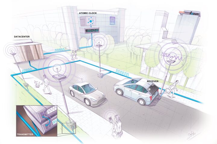 GPS has its limitations in urban areas where signals can get noisy. Now, engineers in the Netherlands have developed “SuperGPS” – a hybrid positioning system that combines wireless and optical connections to pinpoint locations within centimeters.
 -
 Garmin has launched a new Instinct adventure watch called the Crossover that takes a hybrid approach by combining GPS smartwatch functionality with classic analog timekeeping courtesy of luminescent hour markers and watch hands.
 -
 The movements of the Sun, Moon and stars have long been used to keep track of time, and now engineers from the University of Tokyo have proposed a new way to use the cosmos to precisely track time, using showers of particles from cosmic rays.
 -
 In 2018, Garmin launched the ultralight inReach Mini two-way emergency communicator. Now it updates the tiny, satellite-based survival tool into the all-new Mini 2, a palm-sized device with more power for saving your bacon in the backcountry.
 -
 Sandia National Laboratories is developing an avocado-sized vacuum chamber made out of titanium and sapphire that could one day use quantum mechanical sensors to provide GPS-grade navigation without the need for satellites.
 -
 BAE Systems has developed the world's smallest, lightest, and most power-efficient military M-Code GPS receiver. About the size of a postage stamp, the MicroGRAMTM-M can be installed in handheld devices and is resistant to jamming and spoofing.
 -
 Velotton introduced the fairly lightweight Vekkit conversion kit last year for those who can't afford the often high price tags of dedicated ebikes, and now version two has been announced – adding a GPS+LTE module and new battery options.
Load More