Outdoors
Whether you're hitting the open road, setting out on a picturesque trail or spending a day paddling, this is where you can say good bye to the daily grind, set up camp and get in touch with nature.
Latest News
-

SkyNest modular hammock tent works as a whole or in pieces
April 17, 2024The SkyNest combines a hammock, bug mesh net and rainfly in a single package that can be used all together or in its separate components. It's claimed to be roomier than other hammock tents, and easier to set up. -
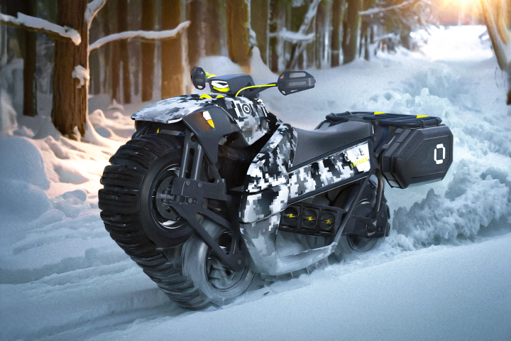
3-wheel tank-track motorcycle crawls over the most brutal terrain
April 17, 2024Bet you haven't seen one of these before! This unique single-track all-terrain vehicle rocks three wheels with massive balloon tires inside a proprietary monotrack system, driven by a grunty electric motor. But... How do you steer the thing? -

Acoustic navigational tech gets scuba divers using GPS maps
April 16, 2024Because GPS doesn't work underwater, divers usually can't track their real-time position on a digital map. The new Diver Navigation System (DNS) gets around that problem, however, using both floating and wearable acoustic transponders. -

All-terrain exoskeleton turns your body into a superhuman e-hiker
April 16, 2024This new recreational adventure exoskeleton welcomes anyone to high-level hiking, scrambling and climbing, upgrading your anatomy with an extra 900 W of leg power. It shoulders up to 83 lb of load, sprints at speeds over 16 mph and packs down small. -
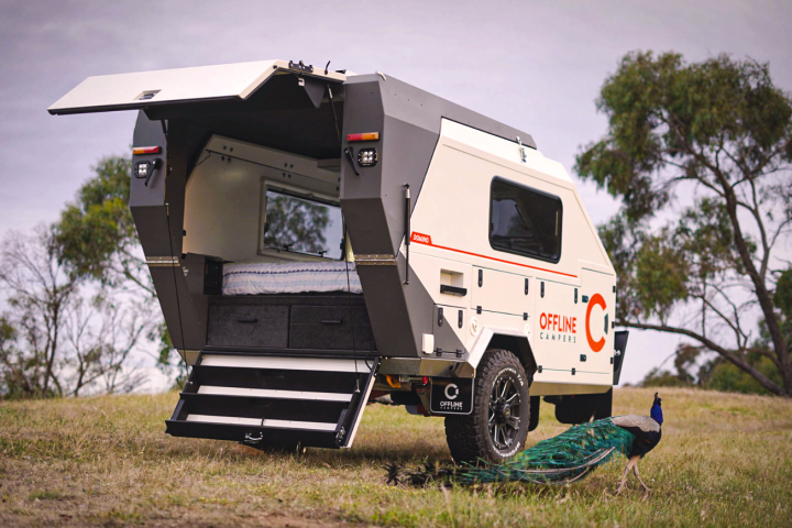
Offline squaredrop camping trailer deploys fold-out cafe and bathroom
April 15, 2024We've previously looked at several Offline camping trailers, and now the builder is preparing a flagship. Still built tough enough for the Outback, the new Solitaire expands to create an ensuite bathroom next to its cafe lounge, kitchen and bedroom. -
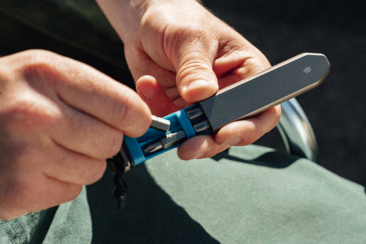
Slim, stashable multitool cranks up the torque for EDC tasks
April 11, 2024The James Brand's new Warrick is part bit cache, part torque-boosting multi-driver. Its slim, flat form makes it easy to slide into the smallest of pockets and carry along the extra torque needed to take care of stubborn screws. -

650-lb micro-camping trailer drifts off-road on wheels or skis
April 10, 2024A tiny, towable nugget ready to explore the natural world behind a passenger car, ATV or snowmobile, the versatile Genimax HR is an affordable tent-top camper built for four seasons of adventure hunting. -

Rifle-inspired titanium multi-tool packs a pen, flashlight and pry bar
April 10, 2024Pens, flashlights and pry bars are all useful, and the BoltLite modular multi-tool packs all three into a waterproof titanium body. It can be carried as one solid unit or pulled into pieces as the situation dictates. -

All-terrain Exoquad gets wheelchair users into four-wheelin' action
April 09, 2024The Exoquad four-wheeler is designed to let wheelchair users independently explore the gnarliest of outdoor environments. And while it packs multiple motors, it has an unpowered sibling that's made for no-holds-barred downhill descents. -
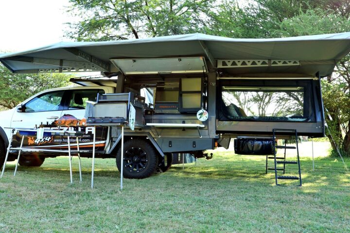
Hogzilla 4x4 expander truck camper doubles in size via sliding bedroom
April 05, 2024That's right, the freakin' HOG ZILLA. It's a pickup camper like no other pickup camper we've seen before, a straightforward flatbed canopy on the road, a blown-out-the-back, multi-room indoor/outdoor living complex when parked. -

Modular multitool lets you carry exactly what you need
April 03, 2024The Roxon Flex isn't like other multitools, in that you decide which tools it incorporates. Up to 10 tools can be added to the base unit, plus others can be purchased and swapped in as needed. -

Kube teardrop camper is a stunning panoramic pod ready for the Outback
March 30, 2024Kimberley Kampers is shrinking its distinctive composite design down from family size to teardrop size. The company's new Kube is a tougher, more luxurious, more compelling breed of two-sleeper small trailer. -
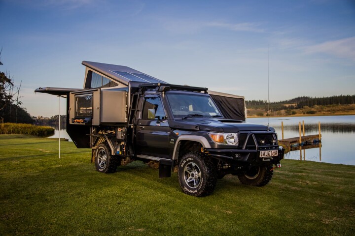
Inkunzi camper makes Toyota Land Cruiser one angry bull of a micro-RV
March 28, 2024The Toyota Land Cruiser remains one of the world's most capable off-road vehicles, and the Infanta 4x4 Inkunzi camper takes that to new heights. The composite canopy adds space to comfortably house, feed, clean and equip a pair of overland drifters. -

Two-in-one magnetic flashlight is ultimate torch for camper couples
March 28, 2024The Dynamic Duo "flashlight" is actually two flashlights – a wide-beam that illuminates a broad area, and a more focused narrow-beam. They can be used individually as needed, or magnetically joined together to form one dual-beam unit. -
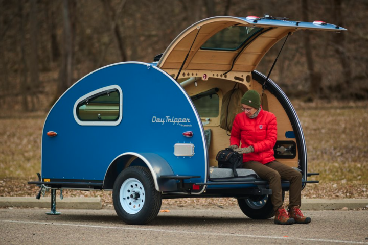
900-lb teardrop trailer distills micro-camping down to its purest form
March 27, 2024Campers don't always need a fancy mobile mansion with high-speed internet. Sometimes, they just want a basic shelter and reconnection with nature. Enter the new Vistabule Daytripper, an extra-tiny teardrop camper that's basically a tagalong bedroom.
Load More