Mobile Technology
In just a couple of decades, smartphones have become indispensable in our daily lives. Read on for news, reviews and comparisons of the latest smartphones and tablets.
Latest News
-

Color e-note tablet makes portable productivity easy on the eyes
April 19, 2024Following the launch of its first e-note last year, PocketBook has now added a color E Ink model. The 10.3-inch Eo is built around Kaleido 3 technology, and sports a built-in camera, octa-core processing and dual speakers. -

Hybrid camera system gives your smartphone "super-telephoto" zoom
April 18, 2024Tech company Beaverlab has launched a Kickstarter to raise funds for a smart super-telephoto camera called the Excope DT1 that can be had with a 400-mm zoom lens, and works with a smartphone to capture distant imagery. -

Logitech simplifies livestreaming with wireless 4K MFT camera
March 20, 2024Ease of use, lens flexibility and Micro Four Thirds image quality is what Logitech is offering digital content creators with the launch of the app-controlled Mevo Core wireless livestreaming camera. -

The first Android 13 E Ink tablet is here: Bigme's full-color InkNoteX
March 19, 2024Bigme has launched a color E Ink tablet that's billed as the first to run Android 13 out of the box. The latest InkNote has access to Google Play, sports a 10.3-inch Kaleido 3 color display with stylus support, and comes packing front and rear cameras. -

Xiaomi launches Leica camera masquerading as a smartphone
February 22, 2024Xiaomi's latest flagship handset has launched in China ahead of an expected Mobile World Congress appearance in Barcelona next week. The 14 Ultra's headline feature is a Leica main camera with a new Sony 1-inch sensor. -

Instant backup device may be perfect for the phone-loser in your life
February 20, 2024If you lose your smartphone, you definitely don't want to lose all the photos and other files stored on it. That's why it's so important to perform backups, and the PhotoCube PD+ offers a particularly simple means of doing so. -
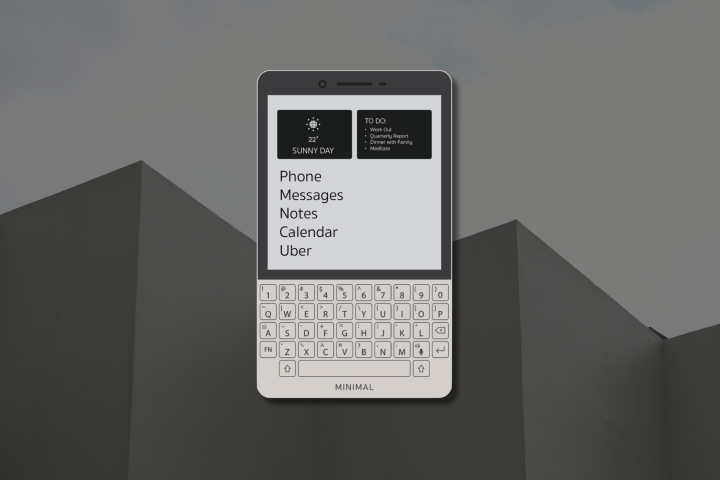
Minimal phone gets back to basics with E Ink display and real keyboard
January 25, 2024We've seen a number of handsets over the years that have been designed to cut down on over-stimulating distractions present on smartphones. The latest looks like a happy marriage between a Blackberry and e-reader, and goes by the name of Minimal. -

Samsung leans into AI power for S24 series smartphones
January 18, 2024Samsung has announced its latest flagship handsets overnight, the S24 series, while also revealing a bunch of AI-powered tools designed to help users with photos and videos, communication, online search and more. -

DJI's wireless mic gets audio quality bump and smart noise cancellation
January 17, 2024DJI has announced an update to its clip-on wireless microphone system launched in April 2022. The Mic 2 now comes with internal 32-bit float recording, noise cancellation and a longer battery life. -

Premium smart binoculars can identify thousands of birds and animals
January 11, 2024Sports optics manufacturer Swarovski Optik has cooked Merlin Bird ID and Mammal ID smarts into a pair of high-end binoculars called the AX Visio to name birds and other critters at the touch of a button. -

Clicks keyboard case makes iPhones more like Blackberries
January 05, 2024One of the big things that set the original iPhone apart from the competition was its onscreen virtual keyboard. That said, Blackberry-style physical keyboards still have some big advantages – and Clicks brings such a keyboard to existing iPhones. -

Fintin offers a non-braille alternative for blind smartphone users
January 03, 2024While blind people are able to enter text into computers via braille keyboards, their options are more limited when it comes to using smartphones. The Fintin V1 is made to help, by compressing a full QWERTY keyboard into six multi-functional keys. -

Vivo improves the imaging formula for X100 series flagship phones
December 15, 2023Hot on the heels of last month's launch in China, Vivo has opened the X100 flagship phones to international markets, each featuring an upgraded Zeiss imaging system, Mediatek's flagship chipset and more battery life. -

Onyx offers note-takers a cheaper monochrome ePaper tablet option
December 12, 2023Back in October, Onyx International announced a pair of 10-inch color ePaper tablets called the Boox Tab Ultra C Pro and the Note Air3 C. Recognizing that not everyone wants color E Ink, the company has now launched the monochrome Note Air3. -

DJI's pocket handicam upgraded with 1-inch sensor and rotating screen
October 25, 2023It's been three years since DJI updated its 4K handicam, and that's clearly long enough as the Osmo Pocket launches into its third generation – coming with a 1-inch sensor, rotating touchscreen, and a significant price hike.
Load More