


Over the last ten years, a new type of malaria has been on the rise in the forests of Southeast Asia, and experts are turning to new technologies to try and figure out why. By using drones to observe the environment from above, researchers are gaining a new perspective on how changes to the terrain may be impacting local wildlife and causing the spread of the disease.
Plasmodium knowlesi is a malaria parasite that has traditionally affected only long-tailed and pig-tailed macaques in the region. But in the last decade, reports have emerged of humans becoming infected while traveling through the rainforests of Southeast Asia. The disease requires immediate diagnosis and treatment, with severe cases having resulted in organ failure and death.
While the cause for this surge is largely unexplored, experts suspect that changes in the landscape are affecting how people, mosquitoes and malaria-carrying monkeys interact. Led by Kimberley Fornace, Research Fellow at the London School of Hygiene & Tropical Medicine, the Monkeybar project is counting on drones to shed new light on how and why these outbreaks are increasing.
"Previously, remote sensing data from satellites has been used to research the spread of malaria but this can be limited by low spatial resolution, frequent cloud cover in tropical areas and long repeat times," Fornace tells Gizmag. "Drones allow us to collect very high resolution geographical data on environmental factors that affect disease without some of these limitations."
Using senseFly eBee drones, the Monkeybar project's research is focused on two sites – Sabah in Malaysia and Palawan in the Philippines. The majority of the Sabah site has been deforested and is experienced significant population growth, with the Plasmodium knowles strain now the number one cause for malaria in humans in the area.
The forests of Palawan on the other hand are mostly intact, and despite being home to the same species of monkeys and mosquitoes with similar ecological conditions, there have been very few cases of humans contracting disease in this area. The purpose of the research is to tease out what is causing the difference in uptake between the two locations.
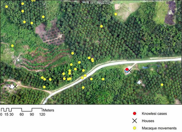
The Monkeybar project combines images collected by drones with hospital records of malaria cases and the movements of the monkeys. This information is then used to visualize how changes in landscape are impacting the movement and population numbers, which could help to better understand why the disease has started to spread to humans.
"While we’re still in the process of conducting the research and don’t have any final results yet, we have been able to observe changes in macaque movement and mosquito numbers in response to land changes and are conducting further work on understanding how this impacts human disease," says Fornace.
The Monkeybar project is slated to run for five years and serves as yet another example of how drones are enabling researchers to approach problems in exciting new ways. In Australia, the CSIRO is using mini-helicopters to track down invasive weeds from the air, in Belize the coastline is being monitored for illegal fishing activity while the Vancouver Aquarium has employed UAVs to observe the behavior of killer whales.
It is still early days for the Monkeybar team, though it has published some observations in the journal Trends in Parasitology.


