Marine

Using GPS to measure changes in sea level

Using GPS to measure changes in sea level
The Chalmers system uses satnav signals to measure sea level
View 3 Images
The new tide gauge measures sea level 20 times a second
1/3
The new tide gauge measures sea level 20 times a second
The Chalmers system uses satnav signals to measure sea level
2/3
The Chalmers system uses satnav signals to measure sea level
The new tide gauge system consists of two antennas housed in white radomes
3/3
The new tide gauge system consists of two antennas housed in white radomes
View gallery - 3 images

Measuring mean sea level is not only an invaluable tool for pilotage, navigation, aeronautics, cartography, sea charting, and geology, it’s also a fundamentally important metric for measuring possible evidence of climate change, and for measuring the direction, extent and rate of such change. Johan Löfgren and Rüdiger Haas of Chalmers University in Sweden have developed a new way of measuring sea level that uses satnav signals for constant, real-time monitoring that promises new insights into many fields, including climate change.

Although mean sea level seems simple to define, it is actually very complex to accurately measure. The geoid, such as the one created by data collected by the Gravity field and steady-state Ocean Circulation Explorer (GOCE), provides a representation of the surface of the Earth's oceans with only the influence of gravity and the planet's rotation to shape them. However, there are plenty of other factors at play. Land masses, the rising of sinking continents and sea beds, ice caps melting, thermal expansion, water salinity, tides, storms, and more can have major effects on sea level measurements.

The new tide gauge system consists of two antennas housed in white radomes

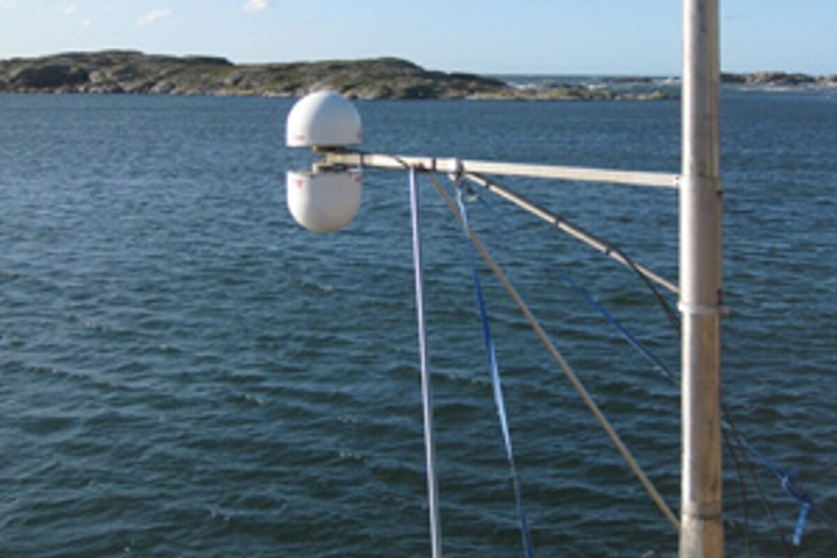
Instead of tide gauges that use electronic sensors in a pipe to measure water level height, the system developed at Chalmers University uses Global Navigation Satellite System (GNSS) radio signals from systems such as GPS, Glonass, and Galileo as a way to directly measure sea level many times a second.

"We measure the sea level using the same radio signals that mobile phones and cars use in their satellite navigation systems," says Löfgren. "As the satellites pass over the sky, the instrument 'sees' their signals – both those that come direct and those that are reflected off the sea surface."

The system uses a pair of antennas housed in white radomes. These pick up satnav signals directly from the satellite and reflected off the water’s surface. By comparing the difference between the two signals, the system is able to measure the sea level 20 times per second.

"Now we can measure the sea level both relative to the coast and relative to the center of the Earth, which means we can clearly tell the difference between changes in the water level and changes in the land," says Löfgren.

The new tide gauge measures sea level 20 times a second

The next step in the program will involve complementing the tide gauge station at Onsala Space Observatory with high-precision instruments to monitor the Swedish coast with millimeter precision. In addition, the team says that the system can work with one antenna instead of two, so it could be adapted for hundreds of existing GNSS shore stations around the world.

"We've successfully tested a method where only one of the antennas is used to receive the radio signals," says Löfgren. "That means that existing coastal GNSS stations – there are hundreds of them all over the world – can also be used to measure the sea level."

The team’s findings were published in the Journal of Geodynamics and EURASIP Journal of Advances in Signal Processing.

Source: Chalmers University

View gallery - 3 images
13 comments
13 comments
Mel Tisdale
What a waste of money and effort. All it takes to stop the sea from rising is to pass a law banning it from doing so, as North Carolina has done.
On a less serious note, I would love to know how they get millimetre accuracy. Is it simply done by taking an average from all the different systems, or is something trickier in play?
Slowburn
Unfortunately nothing facilitates fraud like a change in instrumentation.
Slowburn
If you are worried about sea level rise dredge dirt from the sea bottom (making more room for the water) and place it in low lying coastal regions.
Mel Tisdale
@ Slowburn
Try: http://www.skepticalscience.com/sea-level-rise-predictions-basic.html. I think you will find that your idea of dredging to be somewhat impractical when you multiply the predicted rise by the area to which it will be applied. What is also impractical is that we simply do nothing. We are already having to raise some infrastructure, such as buildings and roads.
@ Slowburn
Perhaps you could expand on your implication that climate scientists are committing fraud with regard to sea-level rise, with whatever evidence you have. I don't think that it is fair to leave the idea just hanging.
bajessup
Archaeologists found a 13,000 year old human skeleton 130 feet below sea level in a coastal Yucatan, Mexico cave. The cave was above sea level when the young woman died in the cave. Therefore sea level has risen more than 130 feet in 13,000 years. (The skeleton is of considerable anthropological significance.) http://www.northwestern.edu/newscenter/stories/2014/05/stunning-discovery-one-of-oldest-human-skeletons-in-north-america.html
Similarly the underwater ocean shelves around Florida's coast were once above sea level. http://www.flheritage.com/facts/reports/contexts/coast3.gif
The issue of a human role in sea level rise due to global warming illustrates how science can have political implications.
Rann Xeroxx
Sea level rise is real and it needs to be measured. The question of causality is a separate debate.
I live in Michigan and we see the evidence of the last ice age all around us. At one time there were almost two miles of ice sitting on top of where I am right now. Something triggered the warming and melting of all that ice and it was not from burning coal. The fact is that sea level rise has been accelerating before the 1950's (the typically agreed point of the start of significant man made CO2 release) and it has in fact been de-accelerating in the past decades.
We are in a inter-glacial period. That means we are actually in the cool period of the Earth. The Earth WILL get far warmer than it is today at some point and we will have nothing to do with it.
srmalloy
Inasmuch as the sea level during the last ice age, which lasted until approximately 12,000 years ago, during which the sea level was almost 400 feet lower than it is now, I find it unsurprising that a skeleton dated to prior to the end of the last ice age might be found in a cave that is now underwater, but would have been well above sea level at the time.
nutcase
Looks like a cheap rival for this http://www.ga.gov.au/earth-monitoring/geodesy/geodetic-techniques/satellite-laser-ranging-slr.html
Bob
Why do they need to measure 20 times a second?
Mirmillion
Great, now we can tell the true sea level in relation to the center of the earth and other reference points. I think we're going to find out that there is wide variation in what we think of as "sea level". This has significant implications in predicting what will happen should sea levels rise. One region, or even geographical area, will not be the same as another. Water temperature, magnetic fields, salinity, acidity and currents (not to mention weather) all play a part.
Load More