Telecommunications

China's Beidou satellite navigation system begins operations

China's Beidou satellite navigation system begins operations
The LM-3C launch vehicle carrying a Beidou satellite into orbit in November, 2010 (Photo: China Academy of Launch Vehicle Technology)
View 2 Images
Coverage area of the Beidou trial currently operating
1/2
Coverage area of the Beidou trial currently operating
The LM-3C launch vehicle carrying a Beidou satellite into orbit in November, 2010 (Photo: China Academy of Launch Vehicle Technology)
2/2
The LM-3C launch vehicle carrying a Beidou satellite into orbit in November, 2010 (Photo: China Academy of Launch Vehicle Technology)

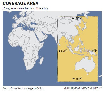
China's independent Beidou satellite navigation system has been operating since 2000, but consisting of just three satellites (and one backup), that first generation system offered only limited coverage to customers in China and neighboring regions. Now, to end any reliance on the US-maintained Global Positioning System (GPS), the second generation of the Beidou system has begun operations. The system currently consists of 10 satellites and covers the Asia-Pacific region, with the number of satellites set to gradually increase to a total of 35 that will cover the entire globe by 2020.

According to China Daily, the Beidou system is currently operating as a free trial and offers positioning accuracy to within 25 m (82 ft). But this is set to improve to an accuracy of within 10 m (33 ft) next year when six more satellites are put into orbit and the system is officially launched for Asia-Pacific customers.

Coverage area of the Beidou trial currently operating

While the GPS system provides location and time information anywhere on or near Earth, Ran Chengqi, director of the China Satellite Navigation Office told China Daily that the Beidou system "not only tells users where they are and what time it is but also allows users to tell others the information through short messages." However, it's unclear whether that capability will be made available to civilians through the free service, or whether it will be limited to the licensed service that will also offer greater accuracy for the Chinese government and military users

The GPS system became fully operational in 1994, but being run by the U.S. government, many countries were concerned that the U.S. could gain a significant advantage in times of conflict by disabling the system. In response to this perceived threat, Russia developed its GLONASS system, whose full constellation of 24 satellites were restored in October of this year, while the European Union's Galileo system is expected to be completed by 2019. Japan and India have also signaled their intention to build independent regional satellite navigation systems.

Source: China Daily

5 comments
5 comments
Michiel Mitchell
competition, the love-child between Capitalism and Greed. now with teeth.
rigjunkie
With all these satellites up there, shouldn\'t accuracy be down around plus or minus a foot?
solutions4circuits
More than the minimum to provide for domestic navigation, particularly for nav coverage over EU and America should be denied to China, as the only reason to put those in is for evil purposes.
Use TomTom like everyone else on the planet does if you want to find a Starbucks, China.
Dawar Saify
During the Russia - Georgia war US disabled GPS and suddenly Russia found itself without navigation, thus all countries now feel threatened and want there own system, and others to be dependent on it for clout. Given the shortage of resources on earth and poverty, with a growing global population, atleast in the field of space, countries can unite, save resources here and spend on earth. 30 30 sets of satellites each for the same task by various countries is ridiculous. All countries should financially contribute towards both a safe and open source, yet highly accurate system universally available and not shut down by anyone, thereby saving precious resources, also each country will also carry out individual research. A central research area should be available to all nations of the world, sharing research. Combine the cost of maintenance and satellite launches, ridiculous sums will be spent.
GeneKern
The Russian Federation's GLONASS system, if you've went from a phone that can see only GPS to one that can see GLONASS and GPS, is why the "Urban Canyon" effect has been much less prominent. Adding a 3rd system, a 3rd frequency, another error check, to the mix, means more reliable positioning across the globe.